How to Delete Rivercast. save (18.36 MB)
Published by Juggernaut Technology, Inc. on 2024-10-24We have made it super easy to delete Rivercast - Levels & Forecasts account and/or app.
Table of Contents:
Guide to Delete Rivercast - Levels & Forecasts 👇
Things to note before removing Rivercast:
- The developer of Rivercast is Juggernaut Technology, Inc. and all inquiries must go to them.
- Check the Terms of Services and/or Privacy policy of Juggernaut Technology, Inc. to know if they support self-serve account deletion:
- The GDPR gives EU and UK residents a "right to erasure" meaning that you can request app developers like Juggernaut Technology, Inc. to delete all your data it holds. Juggernaut Technology, Inc. must comply within 1 month.
- The CCPA lets American residents request that Juggernaut Technology, Inc. deletes your data or risk incurring a fine (upto $7,500 dollars).
-
Data Not Linked to You: The following data may be collected but it is not linked to your identity:
- Identifiers
↪️ Steps to delete Rivercast account:
1: Visit the Rivercast website directly Here →
2: Contact Rivercast Support/ Customer Service:
- 100% Contact Match
- Developer: Juggernaut Technology, Inc.
- E-Mail: apps@juggernaut-tech.com
- Website: Visit Rivercast Website
- 100% Contact Match
- Developer: webdasein
- E-Mail: kontakt@webdasein.net
- Website: Visit webdasein Website
- Support channel
- Vist Terms/Privacy
3: Check Rivercast's Terms/Privacy channels below for their data-deletion Email:
Deleting from Smartphone 📱
Delete on iPhone:
- On your homescreen, Tap and hold Rivercast - Levels & Forecasts until it starts shaking.
- Once it starts to shake, you'll see an X Mark at the top of the app icon.
- Click on that X to delete the Rivercast - Levels & Forecasts app.
Delete on Android:
- Open your GooglePlay app and goto the menu.
- Click "My Apps and Games" » then "Installed".
- Choose Rivercast - Levels & Forecasts, » then click "Uninstall".
Have a Problem with Rivercast - Levels & Forecasts? Report Issue
🎌 About Rivercast - Levels & Forecasts
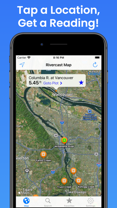
1. Rivercast™ puts the river level data you need at your fingertips with its intuitive and interactive maps and graphs.
2. • Search interface to find river gauges by waterway name, state, or NOAA 5 digit station ID.
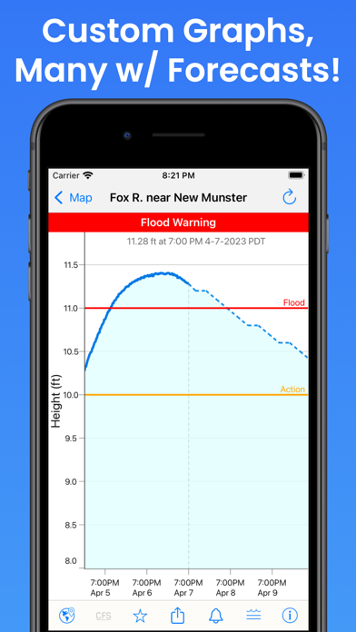
3. • This app uses NOAA and AHPS (Advanced Hydrologic Prediction Service) for its raw data for our custom graphing and mapping solutions.
4. Rivercast™ uses the latest observation and forecast data available, and requires an Internet connection for use.
5. NOAA and USGS estimates may sometimes slightly vary due to using different data models.
6. Rivercast's map not only shows you where the stations are, but color codes them when it can to give you an indication whether the location is at normal levels, approaching flood levels, or above flood stage.
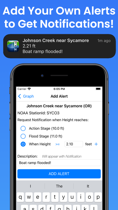
7. Favorites, Map "Instant Observations", and Hydrograph data is viewable in feet or cfs (when available).
8. To customize your graphs for what's important to you, you can add your own level lines to mark things like sandbars, rocks, bridges, safe conditions, or whatever you would like.
9. Stage height should always be identical between USGS and NOAA.
10. • Customize your graphs by adding river levels that are relevant to you.
11. All observation and forecast data is in your local time (per your device) for your convenience.
12. Designated flood stages are based on stage height in feet in the USA.
13. • Map interface that shows where river gauges are located geographically.
14. They occasionally have technical problems transmitting their data, or can even get washed out during extreme flooding.