How to Delete Wildfire Info. save (4.54 MB)
Published by David Gross on 2024-08-12We have made it super easy to delete Wildfire Info account and/or app.
Table of Contents:
Guide to Delete Wildfire Info 👇
Things to note before removing Wildfire Info:
- The developer of Wildfire Info is David Gross and all inquiries must go to them.
- Check the Terms of Services and/or Privacy policy of David Gross to know if they support self-serve account deletion:
- The GDPR gives EU and UK residents a "right to erasure" meaning that you can request app developers like David Gross to delete all your data it holds. David Gross must comply within 1 month.
- The CCPA lets American residents request that David Gross deletes your data or risk incurring a fine (upto $7,500 dollars).
↪️ Steps to delete Wildfire Info account:
1: Visit the Wildfire Info website directly Here →
2: Contact Wildfire Info Support/ Customer Service:
- 100% Contact Match
- Developer: David Gross Apps
- E-Mail: davidgrossapps@gmail.com
- Website: Visit Wildfire Info Website
- 62.07% Contact Match
- Developer: Qvyshift LLC
- E-Mail: support@qvyshift.com
- Website: Visit Qvyshift LLC Website
3: Check Wildfire Info's Terms/Privacy channels below for their data-deletion Email:
Deleting from Smartphone 📱
Delete on iPhone:
- On your homescreen, Tap and hold Wildfire Info until it starts shaking.
- Once it starts to shake, you'll see an X Mark at the top of the app icon.
- Click on that X to delete the Wildfire Info app.
Delete on Android:
- Open your GooglePlay app and goto the menu.
- Click "My Apps and Games" » then "Installed".
- Choose Wildfire Info, » then click "Uninstall".
Have a Problem with Wildfire Info? Report Issue
🎌 About Wildfire Info
1. Lookup current hyper-local weather conditions, including temperature, wind and gust conditions, and local forecasts anywhere in the USA, Canada, or Australia using map quick lookup or, for USA, search: Detailed NWS Forecast, Hourly Forecast, Grid Data Forecast, and Summary Forecast.
2. Premium Users: Lookup a driving route to any fire or hotspot with Google or Apple Maps directions Universal Links.
3. A Recent Wildfire News section: find news from 1,700+ cited sources quickly on a map or in a table view tagged by state alphabetically.
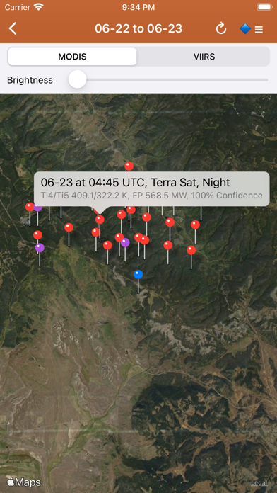
4. NASA MODIS and VIIRS satellite instruments: Thermal hotspot maps by region show wildfire activity in the past 48 hours.
5. There is a section for wildfire-related US government Twitter accounts viewable by map by approximate location or sorted into national and state sources in a table view.
6. Information is posted as soon as it becomes available from WFIGS, IRWIN, NIFC, NASA, InciWeb, CAL FIRE, CHP, NOAA, GOES/NESDIS, EPA, and NWS.
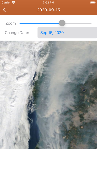
7. NESDIS GOES 16/17 satellite animation GeoColor and Fire Temperature quick links at relatively high resolution.
8. Premium users: View 250m resolution true color images from NASA GIBS (Global Imagery Browse Service).
9. See hotspot info including fire radiance power, brightness temperature, and confidence.
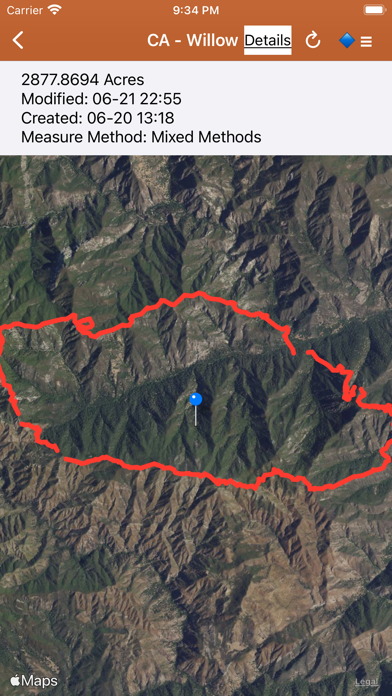
10. Active Wildfire Perimeter full data from WFIGS and IRWIN updated every 20 minutes.
11. InciWeb & CAL FIRE active fire maps: hot-link to the corresponding official incident webpage.
12. CHP (California Highway Patrol): Incidents in the past 3 hours related to fires are filtered out separately, all traffic incidents are included viewable by last 1 or 3 hours.
13. Browse current wildfire and prescribed burn activity throughout all of the world.
14. Wildfire Situation Reports section with mirrored PDFs from NIFC and more.